Sunset from Point Judith 3/21/20

March is a perfect month to go to the beach. Not to swim, of course, but rather to have some quiet time, really meditate to the sounds of the waves crashing, relax. You'd be hard-pressed to find your typical, obnoxious summer crowd on the beach during this time, due to the remnants of winter still blowing-cold along the coast. If you can put the temperature aside, it truly is a great time to be out.

Fisherman's Memorial State Park

Former military fort turned campground, Fisherman's Memorial is a place rich in history. This area was once known as Fort Greene, named after Nathanael Greene, a Revolutionary War general, who served under George Washington during the Siege of Boston.

The base was built in 1943 during World War II, as the first line of defense to any would-be invaders of Narragansett Bay. The site grew to include a few 16"/50 caliber Mark 2 guns (can't say I know what any of those numbers mean, but it sounds menacing). These guns had a range of 45,000 yards, in all directions! Also on base was a plotting room, military bunkers, and a fire control tower disguised as a barn silo.

Looking over Point Judith from atop the old fort.

Another section of the base. Likely to be where
one of the Mark 2 guns were housed.

Certain sections of the base were abandoned after World War II, leading to the state purchasing the property in 1953 with the hopes of turning it into a state park. They were successful in their efforts, and ended up naming it Fisherman's Memorial, to thank all local sport and commercial fisherman who keep Rhode Island's economy alive.

Battle of Point Judith

I can't go any further without acknowledging one of the few battles during World War II which took place off the coast of the United States. As the name implies, the battle transpired right off the rocky cape of Point Judith, in May of 1945.

Several German ships were surveying the American coastline that month, one of which was U-853, a German submarine stationed in Block Island Sound. In the same area was the SS Black Point, a collier ship (designed to transport coal) which was heading for Boston. Without being provoked, the German U-boat fired upon the ship, sinking it immediately.

It took a day of searching, but finally, the German U-boat was located, and bombarded by two blimps and the USS Moberly. The ship had been sunk, everyone on board drowned, succumbing to the cold waters surrounding them. By the end of the battle, 12 Americans had died, along with all 55 passengers of the U-boat. Germany would surrender only two days later.

Some folks say you can see the ghostly apparition of
  the USS Black Point, still in the midst of it's final voyage.


Sunset From Point Judith

The Point Judith area is beyond words, it's one of those "legendary" New England locales that you hear about from tourists. This is with good reason, whether it be a warm summer day or a breezy Saturday night in March, it's surefire way to make memories you'll never forget.

I was with my family that March night, and the sky was beautiful. Bands of color laid across the sky, the bushes were beginning to bud as well, with the ever-present light atop the Point Judith Lighthouse visible for miles. All around, a great experience.

The rocky shore of Point Judith, a cargo ship passing
in the distance.

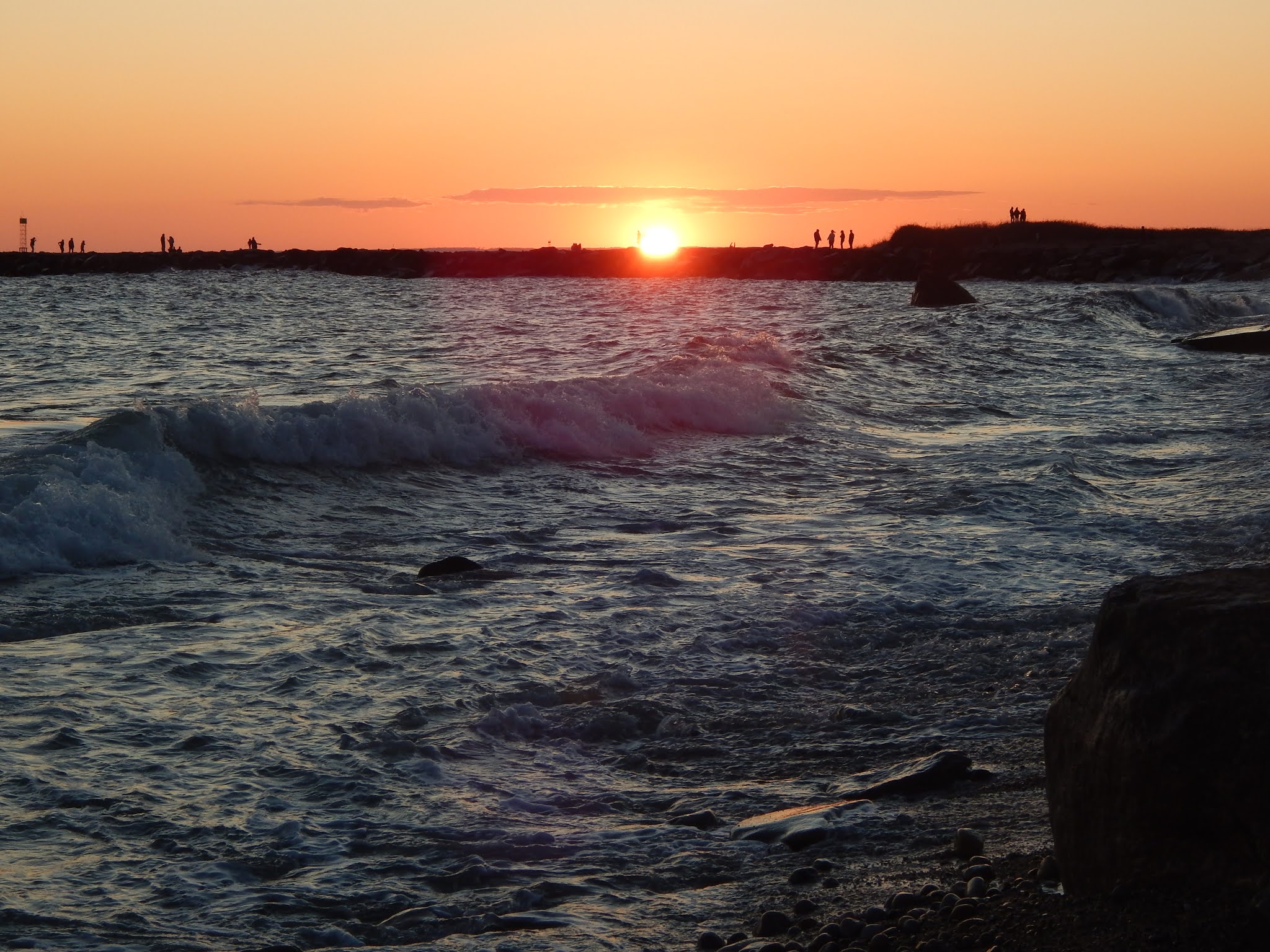
The sun setting over one of the jetties, which was
covered with people.

Me, hoisting a piece of driftwood to the sky!

It really doesn't matter what time of year it is, or what kind of person you are. Almost everybody can find beauty in places like this. And unlike a mountain, which can only be reached by a long, strenuous trail, it's accessible to everybody. Not only does Point Judith have history, but it has plenty of beauty to go along with it.

Mount Carleton and Journey's End 8/23/20

The Long Trail

The Long Trail of Vermont has always stood out to me as the finest example of what a "long distance" trail should be. It runs for a total of 273-miles through the backwoods of Vermont, winding it's way through large boreal forests, over quartzite ledges, and atop the state's tallest peaks, such as Mt.Mansfield and Camel's Hump.

Originally conceived in 1909, the Long Trail's construction lasted from 1910 to 1930, making it the oldest long-distance trail in the United States (the Appalachian Trail wouldn't be finished until 1937). It was built by the Green Mountain Club, who continue to maintain the path to this day. The southern-terminus can be found on the border with Massachusetts, while the northern-terminus can be found along the international border with Quebec.

While I've never thru-hiked the trail, I have been to both ends (almost). A few years ago I ventured out to Pine Cobble in Williamstown, where I came within close proximity to the southern-terminus. Sadly, the temperature that day was an unforgiving 96 degrees, which deterred me from making the brief walk from the cobble to the border.

Mount Carleton

It was a very comfortable summer morning in northern Vermont when my dad and I decided to tackle Mt.Carleton, with a promise of a view at the Quebec border. The air was cool, the roads were quiet, and the fog still lingered above the lowlands. Northern Vermont (specifically the Northeast Kingdom) is such a beautiful area, with sweeping views around every corner.

One of many views from VT-105.

While parked at the trailhead on route 105, I couldn't help but think about all the thru-hikers who have crossed the highway, knowing it's the last road they'll be crossing on their journey.

This particular piece of the Long Trail is very pleasant, meandering over bumpy landscape and through pleasant stands of pine. We made it to the summit in no time.

Through a picturesque pine forest.

I'd looked into Mt.Carleton before, and heard rumors of a pleasant vista from it's piney summit. However, as the years have gone by, the trees have finally started taking the summit back, leaving us with little to no view.

One of two summit signs, marking the elevation.

The "view" from Carleton, long after it's glory.

From here, the trail got very rugged, with large tree roots and rocky terrain disrupting the flow of the trail. It's important that I bring up the latitude 45 degrees sign on this segment of the trail, the half way point between the equator and north pole.

Brand new signs all along the trail!

Journey's End

After a long descent over rocky terrain, I could finally see it, the Quebec border, the northern-terminus of the Long Trail! While it is man-made, the border swath is still able to provide an outstanding view into Canada, specifically to the neighboring peak of Carleton, known as Mont Brock.

Benchmark in the foreground, with Mont Brock
far in the distance.

Commemorative sign discussing the Long Trail.

The Long Trail ends here, but the hike does not. For any thru-hiker who makes it to this point, they must either go back up what they just came down from Mt.Carleton, or take the shorter Journey's End Trail, which leaves to the right of the border.

Even though Mt.Carleton itself lacks a view, the hike is well worth the effort. It's a unique spot, to be able to see where so many hikers celebrate their journey's end. If I ever return here, it won't just be a day hike, that's for sure.

Update: Welcome Back!

It's been a while, hasn't it? A lot has happened since my last post, and I thought I'd write a quick update about what I'll be doing with this blog from now on.

Unlike what I've been doing for the past year, I will not be abandoning this blog. Looking back, I miss writing here, and besides growing tired of the format, I can't think of why I abandoned it in the first place. I even had a few drafts ready to be published, which I've since erased.

I'd like to improve in my writing and my visual storytelling from here on out, and this page is the perfect testing ground. Be ready for a whole new look and writing style from me, one that will be a bit more polished. I've been thinking about changing the name as well, as I no longer want to limit this blog to only hiking, as I've branched out to a great extent over the last year. My posts will likely be shorter, and cover a much wider variety of topics, with more pictures than anything. I will be posting these shorter stories over the next few months, all from my previous years' travels.

Pico Peak 8-24-20


I hope all my readers find this post well, and thank you for waiting an entire year just to read more about my travels.

    -Evan

One Winter Morning: Mt.Kearsarge

It's been awhile, I know. I'm happy to say that I was able to start 2020 with an outstanding hike, and a simple one at that. I decided it was time to head back to an old favorite of mine. Mt.Kearsarge, one of the most prominent peaks in New England, is situated in southern New Hampshire. The views from the summit are outstanding. I don't know what draws me to this mountain, but whenever I end up hiking it, it's always winter.

The summit sign for Mt.Kearsarge has had people carving it for decades now.

Both trailheads for the mountain can be found about halfway up the mountain, with solitary roads that lead up to them. Those roads happen to be closed in the winter, but that's no problem, it's just road walking. The morning was cold, but the snow was firm, making it an easy hike. Once we got to the actual trailhead at Winslow State Park, we found only the Barlow Trail was packed down. We followed this one up, as it made for a better hike up.

The view from the road, toward Mt.Sunapee and it's ski slopes.
Barlow Trail

While the morning started off cold, I couldn't help but notice the sun attempting to heat the air. With the light shining from between the frosted pine trees, and the sound of snow crunching, it couldn't have been more obvious that winter was in full swing. The trail eventually brought us to the junction with the Winslow Trail. As we continued ahead, the first few viewpoints began to open up around us.

The trail junction just before the summit.
One of the first viewpoints, with Ragged Mountain to the right and Mt.Cardigan in the distance.
Toward Ragged Mountain again, with the White Mountains in the background.

My dad and I soon found ourselves emerging onto the summit ledges. Mt.Kearsarge is in the perfect spot when it comes to scenery.It's one of the few spots where both the White Mountains and Mt.Monadnock can be seen very easily. Other visible peaks include Mt.Sunapee, Mt.Ascutney, the Uncanoonucs, Mt.Okemo, Mt.Belknap, and especially Mt.Cardigan.

Approaching the summit.
Mt.Cardigan, in it's snow-capped glory.
Looking south. Mt.Monadnock is on the horizon to the right.
A clearer view north, looking over the snowy summit ledges.
The Ossipee Range, as seen from the bottom of the fire tower.

On the way down, we were able to enjoy the solitude of the mountain. On an average summer day, Mt.Kearsarge is full of people. It seems that winter days don't attract people, as we were the only ones on the mountain all day. It appeared that there were more snowmobiles going up and down the snowy roads than there were hikers on the trail. Maybe that's for the better. Either way, it felt great to be back on the trails.

The Last Sunrise: Bromley Mountain

The time has finally arrived, and our full year of sunrises has come to an end. Last November, my dad and I climbed Mt.Alander for sunrise. Since then, we've been able to get a sunrise from atop a different mountain in the northeast, doing so at least once every month. That first sunrise was only the beginning. Now that a full year has gone by, we've done sunrises just about everywhere, from Camel's Hump in Vermont's Green Mountains, to Mt.Wittenberg in the Catskills, and even two peaks in the Adirondacks. Usually you'd treat an event like this with great respect; making sure the weather will be perfect, and choosing an important mountain. Instead, I made sure to treat our last sunrise like any other hike. We decided to do our last one from atop Bromley Mountain, which is in southern Vermont. While it doesn't rank as our most beautiful sunrise, it definitely wins most unique.


The sunrise behind the ski-lift.

We got to the trailhead a few hours after midnight, with the forest silent and the stars out and shining above us. The path was easy to follow, even with the darkness all around us. We were able to keep track of the blazes, which were everywhere (this section of the path is the Long Trail and Appalachian Trail, after all). It never got steep, and it made for a great, relaxed ending to all the other hikes we've done so far. We passed the lean-to, then emerged onto one of the ski slopes, lit up by the stars above. The lights of Manchester could be seen behind us, with Equinox Mountain visible. We made it up to the summit, where we wandered around the ski-lifts for a while, awaiting the sunrise.


The ski-lift in silhouette over the rising sun.
Peru Peak from Bromley Mountain.
One of many ski-slopes.

As we waited for the sun to appear, I began to take notice of all the early signs of winter. Not only did a fine layer of frost cover most of the equipment, but all the water on the summit was frozen as well. While we were waiting for the break of day, I found many of the huts doors being unlocked, which provided momentary warmth from the freezing winds outside. From the summit could be seen the Coolidge Range to the north, Glebe Mountain to the east, and Stratton Mountain and Glastenbury Mountain to the south.


The ski-lift as the clouds began to move in.

As the wind began to howl, the sun started rising, which lead to the clouds moving in. Usually, an event like this would lead to poor visibility, and in this situation, a lousy sunrise. However, the clouds elevated the experience. As they filled the sky, it appeared the sun was sitting high above a raging fire on the mountain side. Words can barely describe the sight, as it perfectly sat behind one of the ski lifts, putting everything in silhouette. After we watched the sunrise for a while, we tucked away inside the ranger cabin.


The sunrise can be seen through the clouds.
Another view of the sunrise behind the lift.
Some of the chairs in silhouette.

Once the sun had fully risen, we realized the clouds wouldn't leave us, so we began to head down as dawn was breaking. Despite the lack of views from the ski slope, it still made for a beautiful descent. A while after entering the trees, we passed a vista, which offered a decent view toward eastern Vermont. On the way down we were able to admire the trail more. There were many portions that were flooded, but they were pretty easy to avoid.


The Ranger Cabin
The Appalachian/Long Trail north.
The long and winding trail down the slope.
One of the partially flooded sections of trail.

Overall, Bromley Mountain wasn't anything special (despite the truly unique sunrise), and I'm okay with that. Not all things need to finish big, as long as I enjoyed it, I'm fine with it. When it comes to what the future holds for hiking and this blog, I'm unsure of it. I might change the blog slightly, or I might take a break for a while. From Mt.Alander to Bromley Mountain, all I can say is that this wasn't only a great year for sunrises, but it was a fantastic year for hiking in general.

Overnight on the Cohos Trail: the Percy Peaks

The third times the charm, especially with hiking. Our most recent hike described below happens to be our third time doing the Percy Peaks. It took three attempts to finally get it right, this time completing the loop and ascending both peaks. This hike is one of the best loops north of the White Mountains in New Hampshire. This is also the first Columbus Day weekend we've had good hiking weather, which is an added bonus.


The White Mountains from North Percy Peak.

My dad and I began the hike at the southern trailhead, where we followed the trail easily through a beautiful forest. The fall colors were everywhere, adding more beauty to the area. The path was gradual at first, but eventually began to climb up the mountainside, passing over and around numerous slides, yet never getting too steep. There were faint views back through the trees from the slides, but they're nothing compared to the views ahead.


The Percy Peaks Trail.
Lucy crossing a bridge along the trail.
The view from one of the slides.

The path flatten out as it entered the col, which is the gap between the two peaks. We were soon brought to the junction with the Cohos Trail, which we followed a few hundred feet south to a faint herd path. This trail is seldom used, despite the very obvious sign stating that it leads to the summit of South Percy. The path is obscure, as it maneuvers up the steep slope, and very slowly opens up onto the summit. This peak is rarely visited, yet it offers one of the most iconic views north of the White Mountain.


The trail junction.
The spur trail to South Percy Peak.
Still climbing South Percy.
The ledges of North Percy as seen from South Percy.
Goback Mountain and Savage Mountain

After taking in the views for a while, we decided to head over to North Percy. We descended from the south peak and eventually made our way over to the junction with the spur trail up the ledges and to the summit of North Percy. Something I don't understand is how over exaggerated the trail up the ledges is. The trail climbs up the ledges, but never results in climbing, it's easily walk-able the whole way up. If anything, the trail up South Percy is more difficult, but not as beautiful.


The beginning of the ledges.
Lucy climbing up the rocks.
Looking toward Long Mountain and the Mahoosuc Range.

We knew we were approaching the summit as the slope began to flatten, and the sign came into view. This peak offers the best views north of the White Mountains in New Hampshire, offering views into three states. Numerous peaks in Vermont can be seen, including Mt.Mansfield, Burke Mountain, Bald Mountain, Jay Peak, Seneca Mountain, and even East Mountain and it's many radar towers can be seen.


The summit of North Percy Peak.
Burke Mountain, East Mountain, Seneca Mountain, Bald Mountain, and Jay Peak.
The radar towers atop East Mountain.

Many more peaks can be seen in New Hampshire, both to the north and south, including Mt.Moriah, Mt.Washington, Rogers Ledge, The Horn, Mt.Cabot, Mt.Garfield, the Franconia Ridge, Mt.Cannon, and Mt.Moosilauke. The Mahoosuc Range can be seen continuing into Maine, and many more mountains throughout Nash Stream Forest can be spotted from the summit.


Looking north from the summit.
The Mahoosuc Range from North Percy, including Baldpate Mountain,
Old Speck, Mahoosuc Arm, Goose Eye Mountain, Mt.Carlo, and Mt.Success.
The Presidential Range rising above the Pilot-Pliny Range.
Mt.Garfield and the Franconia Range, alongside the Kinsman Range,
as seen from North Percy Peak.

We set up camp just below the summit, and away from the winds. We stuck around the summit, as the sun began to set over the horizon of Vermont. There were still people arriving at the summit, even after the sun had set. After watching the sunset, and taking in the star-filled skies, we went to bed, awaiting the sunrise the next morning.


The colors of sunset over the Mahoosuc Range.
South Percy and the White Mountains.
Watching the sunset over Vermont.

The sunrise was a beautiful sight, as it rose just over the Mahoosuc Range, shining all over the valley and nearby mountain slopes. We admired it for a while, but we also wanted to get down early, so we hastily packed up camp and began to make our way down, enjoying the views over Lake Christine and toward the White Mountains all the way down.

The sun rising over the undercast clouds.
The sun slowly rising.
Lake Christine and the White Mountains
Looking into Vermont from the ledges. Cape Horn can be seen to the left.

Once we entered the trees, we continued down the north side. This trail is beautiful, and not steep at all. It begins by passing through a moss-covered forest, which slowly transitions into hardwood. The Cohos Trail is well marked here, and it eventually brings you to the camping spot, where the Cohos Trail diverges, and we continued on the Percy Loop Trail, which follows an old woods road for the rest of the way.

The junction with the campsite.
Lucy roaming the campsite.
The old woods road through the forest.
Sugarloaf Mountain through the fall-colored trees.

Overall, it was enjoyable hike with great views, making a great second to last sunrise for the year. If you don't know what I'm talking about, it's that my dad and I have been doing a sunrise hike every month since November to celebrate my dad's 50th birthday. We've already done twelve months, but we will officially finish the endeavor next month, completing the year. It's been an exciting experience so far, so hopefully we can finish strong!