Sunrise and Sunset from Mt.Race

Mt.Race is one of the better mountains in lower New England. Many people think of southern New England as being spotted with cities and rolling hills, but Mt.Race and it's neighboring mountains show that that's not always true. The Appalachian Trail even traverses Mt.Race, likely for it's amazing views.


The southern ledges of Mt.Race, during an undercast.

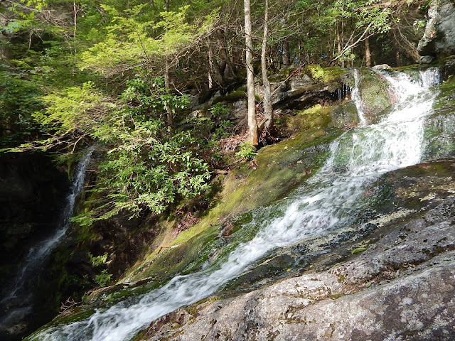
We took the Race Brook Falls trail up the mountain. One of the key features of this trail is, of course, Race Brook Falls. Even though there are several different sections of the falls, the upper and lower falls are highlighted along the trail. The lower falls has a side trail leading to it, while the main trail runs directly underneath the upper falls.


The upper falls.
The lower falls.

After the trail passes the upper falls, it curves up the steep slope and soon arrives at the flat top of the plateau, between Mt.Race and Mt.Everett. The trail entered a scenic, old growth forest, where the brook flows through. A few more waterfalls can be found here.


Some more falls on Race Brook.

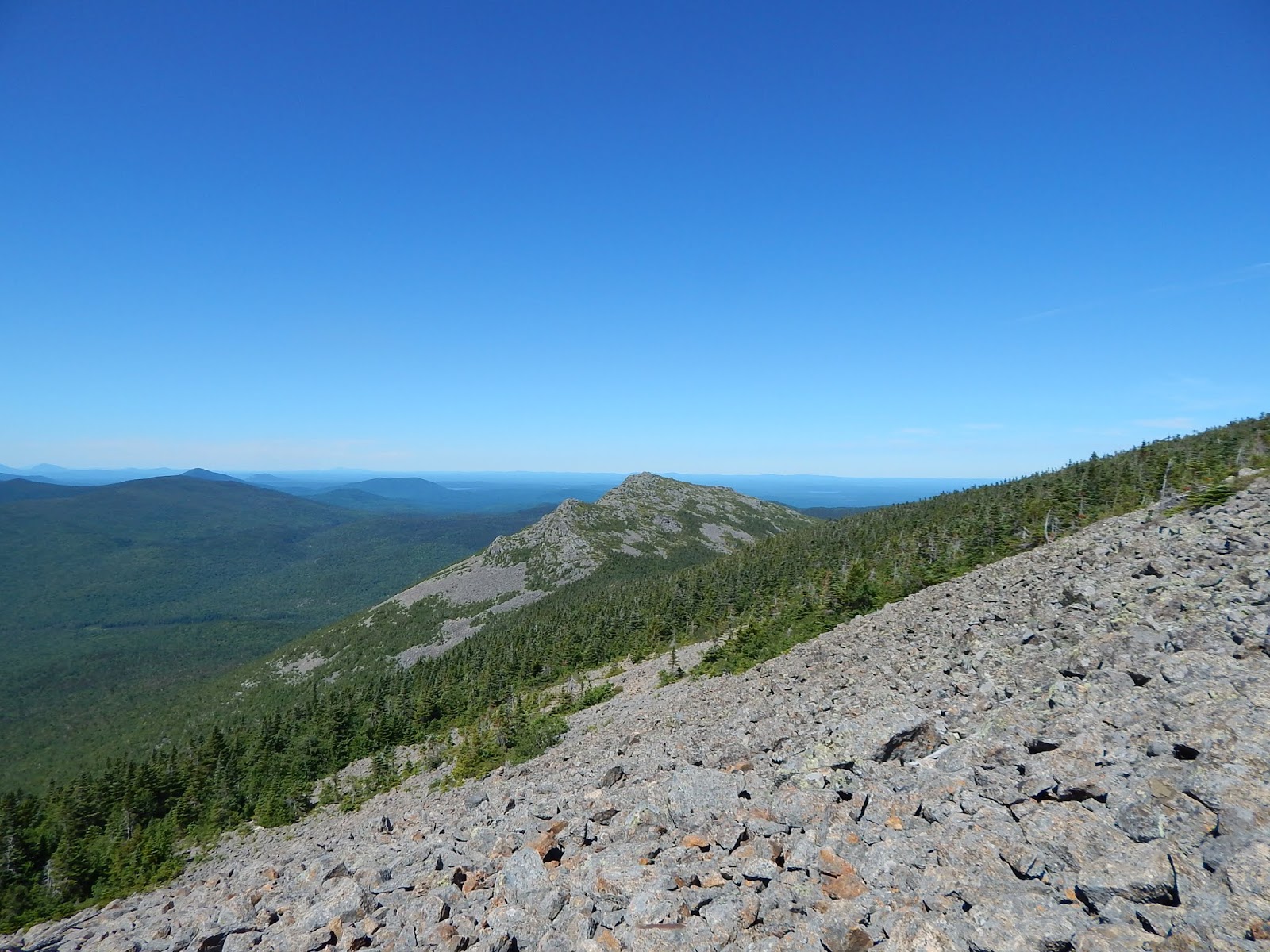
We continued on the trail, and passed Race Brook Falls Campsite. After arriving at the Appalachian Trail, we headed south to Mt.Race. We planned on camping out to watch the sunrise and sunset, and we were arriving a little late. Once we got to the top of the mountain, we saw the sun just above the Catskill Mountains.


The distant high peaks of the Catskill Mountains.

Looking west, we could see Windham High Peak, the Blackead Range, Stoppel Point, Kaaterskill High Peak, Overlook Mountain, and Slide Mountain, the highest peak of the Catskill Mountains, at 4,180 feet. We could also see Mt.Everett and Mt.Greylock up north.


Mt.Greylock, and some more mountains of the Taconic Range.

To the east, the lower Berkshires could be seen, as well as Bear Mountain, Round Mountain and Mt.Frissell to the south. From this spot, we watched the sunset over Windham High Peak, and other distant mountains. Luckily, the clouds didn't block it.


The distant sunset from Mt.Race.

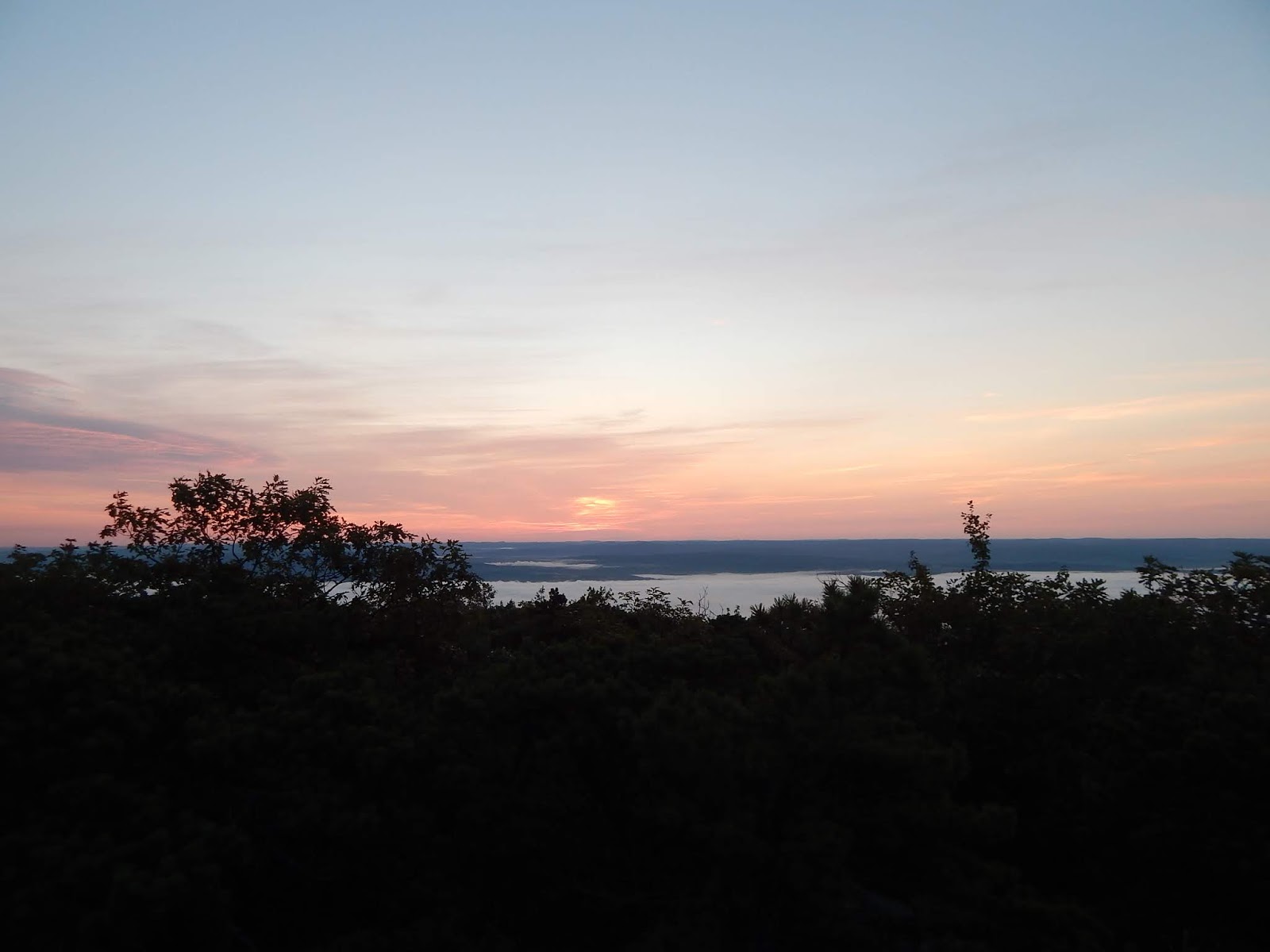
We stayed overnight, and watched the orange moon as it slowly rose up in the night sky. The night was bright, and the stars were out. We awoke early the next morning to watch the sun rise above the Berkshires. It wasn't as nice as the sunset, but it was still worth it.

The sunrise above the Berkshire Hills.

After watching the sunset, we headed farther south on the Appalachian Trail. Once we passed over the open summit, the trail brought us into the trees, then back out to some big open ledges, with views to the east. If you decide to climb Mt.Race, the trip to these lower ledges is well worth it.


GALLERY
Mt.Everett from the summit of Mt.Race.
A closer look at the Catskill Mountains during the sunset.
The orange moon at night.
The early morning sky looking east.
A closer look at the sunrise above the Berkshire Hills.
Mt.Greylock, at dawn.
The rising sun, as it illuminates the sky.
Mt.Alander from the summit.
Bear Mountain, Gridley Mountain, and Round Mountain from Mt.Race.
Looking south from one of the many ledges present on Mt.Race.
Mountains in Connecticut, as seen from the ledge.
The view from another ledge.
Looking back at Mt.Race. Mt.Greylock can be seen in the distance.

Mt.Race is a great mountain, and well worth the time and effort. I've already climbed the mountain, and most of it's neighboring peaks. I hope to soon have a blog about every peak in the range, and be able to do more exploring in the area. When it comes to mountains in Massachusetts, Mt.Race is high up there.

The Traveler and Little Knife's Edge

The Traveler sits high in the northeast corner of Baxter State Park, and it is one of the best mountains I've ever climbed. The mountain is like a small Katahdin, as it has several peaks, and an extensive alpine area. The mountain is also home to Peak of the Ridges, which is also known as Center Ridge. On this peak, sits Little Knife's Edge.


Summit of The Traveler, and Little Knife's Edge to the left.

We stayed a night at South Branch Pond Campground, and it's definitely one of the better campgrounds in the whole park. We stayed right on the shore of Lower South Branch Pond, and from here, there was a good view of the slope of South Branch Mountain and the ledges of North Traveler and Peak of the Ridges.


The Traveler from Lower South Branch Pond.

At the trailhead, they recommend going up the Center Ridge Trail first, so we did. We began the hike by walking along the shore of Lower South Branch Pond. The South Branch of Trout Brook flows from these ponds, and then drains into Grand Lake Matagamon, which then becomes the East Branch of the Penobscot River. You can rent canoes for the ponds, and the trail comes out to a nice shore area for boats.


Lower South Branch Pond from the shore.

The trail started to go up the mountain with limited views to South Branch Mountain. We hooked onto the Center Ridge Trail, and it became somewhat steep and rocky. All the rock on the mountain looks like traprock, much like Mt.Tom in Massachusetts. The Traveler may actually be the largest volcanic mountain on the east coast. The trail came out to a talus field, with good views towards the ponds and to Katahdin.


South Branch Mountain and Black Cat Mountain from the first viewpoint.

The trail goes in and out of exposed rocky spines and talus slopes. With the morning sky illuminating all the distant peaks, and the silence, it made for an amazing experience. From here, we could see Katahdin and Knife's Edge, the South Branch Ponds, South Branch Mountain, and the distant northern peaks of Maine.


Looking south, with Peak of the Ridges to the left, and Katahdin in the distance.

We soon entered the open alpine meadows just below the summit. As the trail climbed over more and more rocks and ledges, we realized how many false peaks there really were. The summit was in sight, and we made the last climb to the summit of Peak of the Ridges.


Peak of the Ridges, and Katahdin.

From here, there was a very good view of the peaks of Baxter State Park, such as Katahdin, Knife's Edge, Hamlin Peak, North Brother, Mt.Fort, Doubletop Mountain, South Branch Mountain, The Pogys, and the rest of The Traveler. Mt.Mooseleuk and Round Mountain could also be seen to the far north.


North Turner, Katahdin, and North Brother from Peak of the Ridges.

Looking towards The Traveler, we could see our next destination, Little Knife's Edge. Much like Knife's Edge on Katahdin, this is a thin spine of sharp rock that stretches down the ridge towards The Traveler. This one isn't as high up or as thin as the one on Katahdin. The entire way on the edge, there is a good view to North Traveler and Katahdin.


Little Knife's Edge, with North Brother and Mt.Fort in the background.

There are several sharp knobs to Little Knife's Edge, and the trail doesn't always follow the top of the ridge, and it usually follows just above the cliff, looking south. The trail then dropped down into the col, and then climbed up to open, rocky slopes of The Traveler, with views back to Little Knife's Edge and Katahdin.


Little Knife's Edge from the slope of The Traveler.

We found ourselves on the completely bare summit of The Traveler, which is 3,540 feet tall. From here there was an amazing view, in every direction. We could see North Traveler, Little Knife's Edge, North Brother, Mt.Fort, The Klondike, Katahdin, and North Turner.


Looking at North Traveler and Traveler Ridge.

Unlike Peak of the Ridges, no mountain was blocking the views to the east, so we could see Mt.Chase, Sugarloaf Mountain, Deasey Mountain, Lunksoos Mountain, Grand Lake Matagamon, and the Fowler Ponds area, to the north. There was also a clearer view of Knife's Edge and Russell Pond.


The peaks of southern Baxter State Park, including Katahdin.

After enjoying lunch, we headed down the summit, and our next destination was the peak between The Traveler and North Traveler, called Traveler Ridge. The trail brought us down the east slope of The Traveler, and the entire thing was bald and open, with views over to Mt.Chase. There were so many meadows and ledges, and it made the hike so beautiful.


Mt.Chase and Sugarloaf Mountain from The Traveler.

We were brought down to the wooded col, then back up to the bald summit of Traveler Ridge. From the ridge, we could see Mt.Chase, North Traveler, Bald Mountain, Billfish Mountain, Trout Brook Mountain, and Horse Mountain. South Branch Mountain and Peak of the Ridges came back into view.


Looking up Traveler Ridge after emerging from the col.

The trail once again dropped into the wooded col, and we began our final ascent to North Traveler. This peak was much different compared to the other peaks, as the summit area was covered with alpine vegetation and a ton of talus. The entire summit was doused with small pieces of rocks, and views could be had looking east, south, and to the west.


The Traveler and Peak of the Ridges from North Traveler.

From the summit, the trail works it's way down meadows and over ledges, with views over the South Branch Ponds. Most people only hike to these ledges for views, but they don't know what's waiting on the rest of the loop.


GALLERY
Lower South Branch Pond from Center Ridge.
North Traveler from Center Ridge.
The summit of Peak of the Ridges.
Looking over Little Knife's Edge.
A closeup of Katahdin from Little Knife's Edge.
A knob of Little Knife's Edge.
Looking back to Peak of the Ridges.
Little Knife's Edge
On Little Knife's Edge.
From inside the col of Peak of the Ridges and The Traveler.
The bald summit of The Traveler, with Deasey Mountain poking out in the distance.
The summit, with North Traveler in the background.
Deasey Mountain and Lunksoos Mountain from The Traveler.
Sugarloaf Mountain, and taller Mt.Chase.
The Traveler from Traveler Ridge.
The summit of Traveler Ridge.
Bald Mountain and Billfish Mountain, with Trout Brook Mountain in the back.
The barren summit of North Traveler.
Looking back up North Traveler.
The slopes of North Traveler, with the hills and ponds of northern Maine in the back.
A lower ledge and a cairn on North Traveler.
Another low ledge, looking back at The Traveler.
Katahdin and Upper South Branch Pond from the ridge.

I think The Traveler is one of the best mountains in New England, and it's definitely the second best in Baxter State Park behind Katahdin. If your wondering about how The Traveler got it's name, it was named by loggers who traveled the East Branch of the Penobscot River, and witnessed the mountain appearing to move. This mountain is also on my 42 With A View list, which is atop my blog.