Mt.Adams has a variety of different routes that can be taken to ascend it. The Randolph Mountain Club controls quite an extensive trail system on the northern side of the mountain. Some of these trails happened to be on the Terrifying 25 list, a list of 25 hiking trails in the White Mountains that are known for being difficult/exciting. On this trip, I planned to ascend Kings Ravine and descend using the Airline Trail, while revisiting the summit of Mt.Adams. The last time I was on the summit of Mt.Adams was actually when I finished the New Hampshire 48.
 |
| A view of Mt.Madison and the Mahoosucs to the left. |
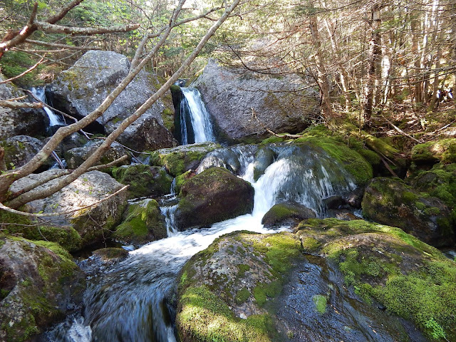
Instead of taking the quickest route to the top, my dad and I chose to visit some waterfalls on the way up. We went up Snyder Brook, which is home to three waterfalls. These falls include Gordon Fall, Salroc Fall, and Tama Fall. Tama Fall is the tallest, at 35 feet.
 |
| The 12 foot drop of Gordon Fall. |
 |
| A portion of Salroc Fall. |
 |
| The 35 foot drop of Tama Fall. |
After visiting the falls, we hooked onto Randolph Path, which obviously doesn't get as much use as other trails as it leads from the falls to Short Line Trail. We followed Short Line Trail from here to the base of Kings Ravine and Mossy Falls. Though obstructed a bit, Mossy Falls was yet another beautiful site along our journey.
 |
| The lower portion of Mossy Falls. |
 |
| The upper section of the falls. |
From here, Kings Ravine Trail starts a boulder filled ascent to the alpine zone. As we reached the rocky ravine, we achieved some great views looking north at Mt.Randolph and the Pilot/Pliny Range.
 |
| Looking north, with Mt.Randolph to the right and the Pilot-Pliny Range to the left. |
After a while, we reached the junction with Chemin des Dames (Trail of the Ladies) and the Subway. The Subway and Kings Ravine Trail are both on the Terrifying 25 list, and there's good reason for this. The Subway branches off the Kings Ravine Trail, and it winds through many caves and boulders. We took it, and it was a real treat.
 |
| From inside the Subway. |
 |
| From atop the Subway. |
There are some tight squeezes in the trail where my dad had to take off his backpack and pass it to me so he could fit through the caves. Some of the crevasses in the caves were filled with ice from the past winter. The Subway itself is quite short, but if your nervous in certain sections or wearing a big pack, it may take longer then expected.
 |
| One of the tight squeezes. |
 |
| Probably the tightest of all the spots. |
Once we had passed through the entirety of the Subway and hooked back onto the Kings Ravine Trail, we came across the Ice Caves. We were going to go through them, but since there was still a ton of ice and slick rocks inside, we didn't go through.
 |
| Looking into the ice caves of Kings Ravine. |
The trail starts a steep and rocky ascent up Kings Ravine. The lower portion includes large rocks and great views looking back down to the Subway and Crag Camp up above the ravine. We could also see the remaining portions of snow lying high above on the ridge.
 |
| Kings Ravine, as it rises above us. |
Now the upper portion of the ravine is different. The trail ascends a gravely slide with very poor footing. We were able to climb up the large rocks alongside the slide, but even this was loose. As a warning, if there are people behind you, be aware of dislodging rocks. Many large cliffs also rise up around the trail at this point, and there's a nice display of flowers.
 |
| The Kings Ravine Trail. |
 |
| More of the trail. |
We reached the Airline Trail and followed it to the summit of Mt.Adams. As I said in the beginning, Mt.Adams is where I finished the New Hampshire 48 last year, so of course the mountain is important to me. From the summit, we could see Mt.Cabot, the Carter-Moriah Range, Mt.Washington, Mt.Carrigain, Mt.Jefferson and even Burke Mountain all the way in Vermont.
 |
| Wildcat Mountain, with the Doubleheads and Kearsarge North behind it. |
 |
| Mt.Washington, Mt.Clay, and Mt.Jefferson, with Crawford Notch visible in the background. |
The summit was pretty crowded due to the beautiful weather. Many people on the summit began to head down to Madison Spring Hut, so we eventually got the summit all to ourselves. We began our descent on the Airline Trail, another trail on the Terrifying 25 list. The trail was pleasant. as it traveled atop the cliffs above Kings Ravine.
 |
| The cliffs of the Airline Trail from Kings Ravine. |
On the trail, we had a great view looking back to Mt.Madison and Madison Spring Hut. Many cliffs and overhangs hovered above Kings Ravine. The trail is very scenic, and it's clear why its a popular trail.
 |
| Looking up the Airline Trail. |
Once we dipped back into the trees, we passed through several areas that could use some work, as many trees had toppled over onto the trail. The caterpillars were also butchering the trees, and they were practically carpeting the ground with all the chewed up leaves.
GALLERY
 |
| Notice Crag Camp on the ridge, high above the ravine. |
 |
| Above the Subway. |
 |
| A waterfall alongside the ravine. |
 |
| This is where the Subway comes out. Can you tell? |
 |
| Mt.Madison and Madison Spring Hut. |
 |
| Looking north. The mountain along the ridge with the talus field is Mt.Cabot. |
 |
| Mt.Madison and the Carter-Moriah range to the east. |
 |
| Looking down Airline Trail! |
Overall, it was a very scenic day. We were staying in Attitash at the time, and I wasn't able to write this blog until now, so sorry if it sounds a bit too third person. It was definitely an exciting day full of thrills and great views. Also, being able to knock off three Terrifying 25 trails was quite thrilling. I should have many new blogs coming out very soon!


No comments:
Post a Comment