The Southern Taconics are a group of lesser known peaks in the far southwest corner of Massachusetts (with some portions extending into New York and Connecticut) As I said in my entry on Mt.Race, this area is often overlooked by hikers who don't live in it's vicinity. The range happens to be my favorite area to hike in lower New England, and with good reason. The area has a distinctive environment, and unique views like no other, especially when done for sunrise and sunset.
 |
| The sunsets between the Shawagunks and Catskills. |
We were hoping to start at the state line trailhead on East Rd, then go over Round Mtn, Mt.Frissell, Brace Mountain, then go all the way up to Mt.Alander and stay in the cabin for a sunrise and sunset. We arrived at the trailhead very early, and hurried up Round Mountain. The trail was flat until we got to the steep and rugged slope of the mountain. Once we arrived at the open summit, the sun began to poke out from behind Bear Mountain!
 |
| The sunrise from Round Mountain. |
 |
| Another photo of the sunrise. |
Round Mountain (2,296') has views in every direction from it's ledgy summit area, with some exceptional ones to the east and south, toward Bear Mountain, Lions Head, Riga Lake, and Brace Mountain. Other peaks that can be seen include Mt.Everett, Mt.Race, and the next peak, Mt.Frissell.
 |
| The view toward Mt.Everett and Mt.Race. |
 |
| The summit of Round Mountain. |
 |
| Looking south into Connecticut and toward Riga Lake. |
After watching the sunrise, we descended Round Mountain only to immediately start ascending Mt.Frissell (2,454'). The trail is steep, and icy in places, so be careful this time of year, especially when climbing these jagged areas. My dad and I were relieved to reach the summit, as we both had are large overnight packs on. The true summit is in Massachusetts, and it's marked by a sign and register.
 |
| Lucy on the summit of Mt.Frissell. |
After going a few hundred yards more down the path, we came to the viewing area. From here, there are great views toward Bear Mountain, Round Mountain, Lions Head, Riga Lake, and Brace Mountain. On these ledges, you can find the high point of Connecticut, marked by a cairn and benchmark. Yup, the highest point of Connecticut is on the slope of a mountain in Massachusetts! I've already been here, so there was no need to log in again.
 |
| Lucy enjoying the views from Mt.Frissell. |
 |
| Looking back at Round Mountain and Bear Mountain. |
 |
| The highest point of Connecticut. |
Once we took enough photos, the trail delivered us onto a large ledge with direct views toward the high peaks of the Catskills. Peaks that can be seen include Overlook Mountain, Plattekill Mountain, Kaaterskill High Peak, Stoppel Point, and Blackhead, all of which exceed 3,000 feet, making them appear much taller then they are.
 |
| The distance peaks and ridges of the Catskills. |
The trail descended, and the sky got brighter. We pushed are way through the mountain laurel until we came across the next point of interest, the tripoint marker. The proud, concrete prism stands in the middle of the trail, marking the only point where the states of Massachusetts, Connecticut, and New York meet. I'm sure this is busy on a summer day!
 |
| Photo of the 1898 side, taken from New York. |
A little while after that, we came to the junction with the Ashley Hill Trail, and then the junction with the Southern Taconic Trail, which brings you to a large field atop the ridge. From here, we overlooked the Hudson Valley, with the Catskills and Shawagunks in the distance. This view is nothing compared to Brace Mountain, the next peak.
 |
| The Hudson Valley from the meadows. |
 |
| Another photo of the valley. |
To get to Brace Mountain (2,310') from the field, we followed the trail south for three tenths, until the trail dropped us onto the summit. The summit of Brace Mountain is distinct, as it's covered in grass with views farther into New York. The summit is marked by a large cairn with a windsock. The winds were strong and cold, so we didn't spend as much time as I would've wanted to up there.
 |
| The summit of Brace Mountain. |
 |
| The true summit is marked by the windsock. |
From the top of Brace Mountain, you can see Mt.Alander and Mt.Frissell, two other peaks on our trip. When it comes to distant peaks in New York, the Catskills and Shawagunks can be seen yet again. Mt.Greylock is clearly visible to the north.
 |
| The Catskills are clearly visible from the top. |
 |
| Mt.Alander from Brace Mountain. |
After a delightful time on the summit, we followed the Southern Taconic Trail north to Mt.Alander, the next summit. The trail is wide and flat all the way, with many flooded areas, most of which were frozen. It really slowed us down, but we were still making exceptional time.
 |
| The trail heading toward Mt.Alander. |
 |
| And Lucy. |
We arrived at the junction below Mt.Alander, but the Alander Loop Trail was closed, so we had to proceed down the Southern Taconic Trail to achieve the views from Mt.Alander. The trail was strenuous as it climbed the slope, but the first view was incredible, as it looked out into the farmland of New York.
 |
| The view toward the Catskills from Mt.Alander. |
It was quiet, and the ridge is open all the way up to the summit. The ledges give the best view of the Catskills in the area. Other things that can be seen include the Shawagunks and Bonticou Crag, the Catskill Mountains, Brace Mountain, Mt.Frissell, Mt.Everett, and even Mt.Greylock to the north.
 |
| Looking up the ridge of Mt.Alander, toward more ledges. |
 |
| The above peaks are Mt.Ashley, Mt.Frissell, and Brace Mountain. |
The summit of Mt.Alander (2,238') completely open, like the rest of the ridge, with restricted views to the north. There are still fire tower footings sitting atop the mountain, which mark the former site of the Mt.Washington Fire Tower, which was built in 1928. A few hundred feet from here is the junction, which, if you keep following the Southern Taconic Trail, will lead you to another large viewpoint, with a grand view of the Catskills and Mt.Everett. There is also a direct view north toward Mt.Greylock, Berlin Mountain, and Monument Mountain.
 |
| Working our way up to the summit. |
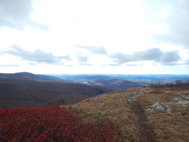 |
| The primary view from the summit. |
 |
| Mt.Everett from the summit. |
Once we descended from the junction, we entered a gap, which is home to the Mt.Alander Cabin. This cabin was used in conjunction with the firetower by the warden. It wasn't in best shape, but when you understand that it's from 1928, you realize it's in good shape. It was fully stocked with in date Pringles and soup cans. This is where we ended up sleeping.
 |
| The cabin on Mt.Alander. |
 |
| The inside of the cabin. |
We were there to watch the sunset, which set at 4:30. Here's the thing, we got there at 11:00, so we had plenty of time to gather wood and explore the cabin. There are four bunks, and a wood stove with very bad ventilation. After talking to many passing hikers, the sky fell darker, and we quickly hurried to the summit.
 |
| Mt.Frissell and Brace Mountain during sunset. |
The sun was slowly lowering itself right between the Catskills and Shawagunks, and the sky lit up with beautiful color. It was just us, the sun, and two others on a lower ledge taking photos. It was so quiet, and wonderful to watch the sun's journey throughout the day.
 |
| The sun slowly setting. |
 |
| The sun sets between the two ranges. |
 |
| The Catskills after the sunset. |
The sun set early, and we headed back to the cabin, made dinner, and fell asleep. I got a good eleven hours of sleep, while my dad wasn't so lucky. We awoke early and headed up to the summit to watch the sunrise. The sky was being illuminated by pink and yellow sunbeams, it was magnificent. As I raised my camera to take a photo, it malfunctioned and stopped working ☹️. Don't worry though, my dad took photos!
 |
| The sunrise from Mt.Alander. |
After watching the sunrise, we had breakfast and packed up camp, now heading for Ashley Hill Trail. My camera still didn't work throughout our entire trip through the forest, so I have no photos of it. There was a very pleasant and secluded primitive camping area with eight sites. The Ashley Hill Trail was easy walking, but once it got close to the Mt.Frissell Trail, it began to get overgrown and flooded, but not for long. We got back to the tripoint, then the ledge on Mt.Frissell where I took my first photo all day.
 |
| My first photo during the second day. |
At the end of the day, we made it out alive. It was around seven miles the first day, and eight the second. It may seem like a long hike, but it was my second time doing this one. The first time was a day trip, and we started up Roberts Brook Trail instead. So if you want to do this hike, but not stay overnight, start from there.
 |
| The trail going up Mt.Frissell. |
The Southern Taconic area is bountiful with unique geography and grand views like no other place in New England. It's unique in it's views and location, as the peaks are split between each state (Round Mountain CT, Frissell and Alander MA, and Brace NY). With the addition of a tripoint, highpoint, and cabin, it makes the area that much better. If you find yourself in the area, check it out. Don't forget to comment below. I can't praise this range enough!


