Showing posts with label NE 50 Finest. Show all posts

One Winter Morning: Mt.Kearsarge

It's been awhile, I know. I'm happy to say that I was able to start 2020 with an outstanding hike, and a simple one at that. I decided it was time to head back to an old favorite of mine. Mt.Kearsarge, one of the most prominent peaks in New England, is situated in southern New Hampshire. The views from the summit are outstanding. I don't know what draws me to this mountain, but whenever I end up hiking it, it's always winter.

The summit sign for Mt.Kearsarge has had people carving it for decades now.

Both trailheads for the mountain can be found about halfway up the mountain, with solitary roads that lead up to them. Those roads happen to be closed in the winter, but that's no problem, it's just road walking. The morning was cold, but the snow was firm, making it an easy hike. Once we got to the actual trailhead at Winslow State Park, we found only the Barlow Trail was packed down. We followed this one up, as it made for a better hike up.

The view from the road, toward Mt.Sunapee and it's ski slopes.
Barlow Trail

While the morning started off cold, I couldn't help but notice the sun attempting to heat the air. With the light shining from between the frosted pine trees, and the sound of snow crunching, it couldn't have been more obvious that winter was in full swing. The trail eventually brought us to the junction with the Winslow Trail. As we continued ahead, the first few viewpoints began to open up around us.

The trail junction just before the summit.
One of the first viewpoints, with Ragged Mountain to the right and Mt.Cardigan in the distance.
Toward Ragged Mountain again, with the White Mountains in the background.

My dad and I soon found ourselves emerging onto the summit ledges. Mt.Kearsarge is in the perfect spot when it comes to scenery.It's one of the few spots where both the White Mountains and Mt.Monadnock can be seen very easily. Other visible peaks include Mt.Sunapee, Mt.Ascutney, the Uncanoonucs, Mt.Okemo, Mt.Belknap, and especially Mt.Cardigan.

Approaching the summit.
Mt.Cardigan, in it's snow-capped glory.
Looking south. Mt.Monadnock is on the horizon to the right.
A clearer view north, looking over the snowy summit ledges.
The Ossipee Range, as seen from the bottom of the fire tower.

On the way down, we were able to enjoy the solitude of the mountain. On an average summer day, Mt.Kearsarge is full of people. It seems that winter days don't attract people, as we were the only ones on the mountain all day. It appeared that there were more snowmobiles going up and down the snowy roads than there were hikers on the trail. Maybe that's for the better. Either way, it felt great to be back on the trails.

Sunrise and Sunset: White Cap Mountain

The 100-Mile Wilderness is one of the most notorious sections of the Appalachian Trail. Many lakes and ponds are passed along the way, and a few mountains are scaled, including the tallest peak in the area, White Cap Mountain. The broad, open summit area offers outstanding views all over the mountainous terrain of northern Maine.


Sunset over Baker Mountain from White Cap.

There are a few different routes to access the summit of White Cap Mountain. We were going to take White Brook Trail, but it turned out to be closed due to logging, so we headed for the northern trailhead on the Appalachian Trail. After having some difficulty following the roads (as it was our first time in the region) we found the trail and began up the northern side of the mountain.


Appalachian Trail sign.
The trail heading up White Cap Mountain.

The trail was relatively flat the whole way, never getting steep. The hike was surprisingly easy for such an infamously grueling sector of the Appalachian Trail. About half way up we stumbled upon Logan Brook Lean-To. After the camp, the trail followed the "Stairway To Heaven" an extremely well put together set of stone stairs that are seemingly never ending.

A portion of the stairway.

Eventually, we were lead to the first viewpoint, which looked toward Katahdin. The trail flatten then lead further and further up the staircase easily until it emerged out into an alpine meadow, and curved up the side of the mountain until it reached a craggy meadow with views toward Katahdin, Jo-Mary Mountain, and the many lakes of Millinocket.

The first viewpoint toward Katahdin.
Climbing higher and higher.
One of the best portions of it can be seen here.
Katahdin in the distance with Jo-Mary Mountain to the right.

The trail wrapped around the small cluster of trees atop the mountain until it reached a large scree field and the summit sign. From the scree field there were excellent views looking toward West Peak, Hay Mountain, Baker Mountain, Elephant Mountain, and Big Moose Mountain visible in the distance. Coburn Mountain can be seen all the way out.

The view west toward West Peak and Hay Mountain.
Baker Mountain is tallest to the right.

Looking south can be seen the Chairback Range, with peaks such as Barren Mountain, Fourth Mountain, Third Mountain, Columbus Mountain, and Chairback Mountain. Saddleback Mountain can be seen to the southeast, with Moxie Bald Mountain and the Bigelow Range visible to the southwest.


The Bigelow Range (tallest) with Mosquito Mountain in front of it.
Saddleback Mountain with Little Spruce Mountain to the right.
The Chairback Range can be seen in the distance.

From the summit sign the Appalachian Trail continues into the trees past the summit, but we stopped here to find a spot among the trees to pitch the tent. There was a side trail that wound through the trees to a large meadow looking north to Katahdin and the Debsconeag Lakes region. The Spencers and First Roach Pond can also be seen.

The summit sign.
The large body of water is First Roach Pond. The two peaks behind it are the Spencers.
Mt.Shaw can be seen to the right.

Throughout the trees and scree fields can be found several remnants of the former fire tower. From wooden planks to broken glass, and even large rusted bolts, it's impossible to miss the towers remains. After rummaging through the trees we found a small building with solar panels and even more remnants of the tower.

The structure atop White Cap Mountain.

It didn't take long for us to set up camp. From the northern outlook we could see large clouds of rain moving east, and we were worried we would be hit with rain. Luckily, it held up just long enough for us to witness a beautiful sunset over the many peaks visible from the scree fields. Once the sunset was over, the wind picked up, and we entered the tent.

The mountains before sunset.
The mountains during sunset.
The sun beneath the horizon.

We awoke the next morning to see the sunrise, which rose beside Jo-Mary Mountain. Large clouds of mist were flying past us through the sky at fast speeds. We could see rain coming, and it slowly moved it's way right over us. The sunrise was beautiful, but we had to get out of the rain and wind, so we hurried off the summit.

The Spencers before sunrise.
The colors of the sunrise are visible.

While both the sunrise and the sunset were absolutely gorgeous, the weather was a big negative. The first day was good, aside from cloudy northern skies over Katahdin. The only view we were able to get the second day was the sunrise. After that, clouds rolled in and the rain came down harder. The mountain was very beautiful, but I wish I could've enjoyed it more. Either way, it was worth it, and the views were great.

Abandoned in the Mountains: Overnight Atop East Mountain

About a month ago, I had the opportunity to climb East Mountain in Vermont, and explore the defunct Lyndonville Air Force Station atop the mountain. I even wrote a blog about it. The second I saw the place in person, I knew I would have to return. I had no clue that it would only be a month until our next visit, and that we would be staying overnight.


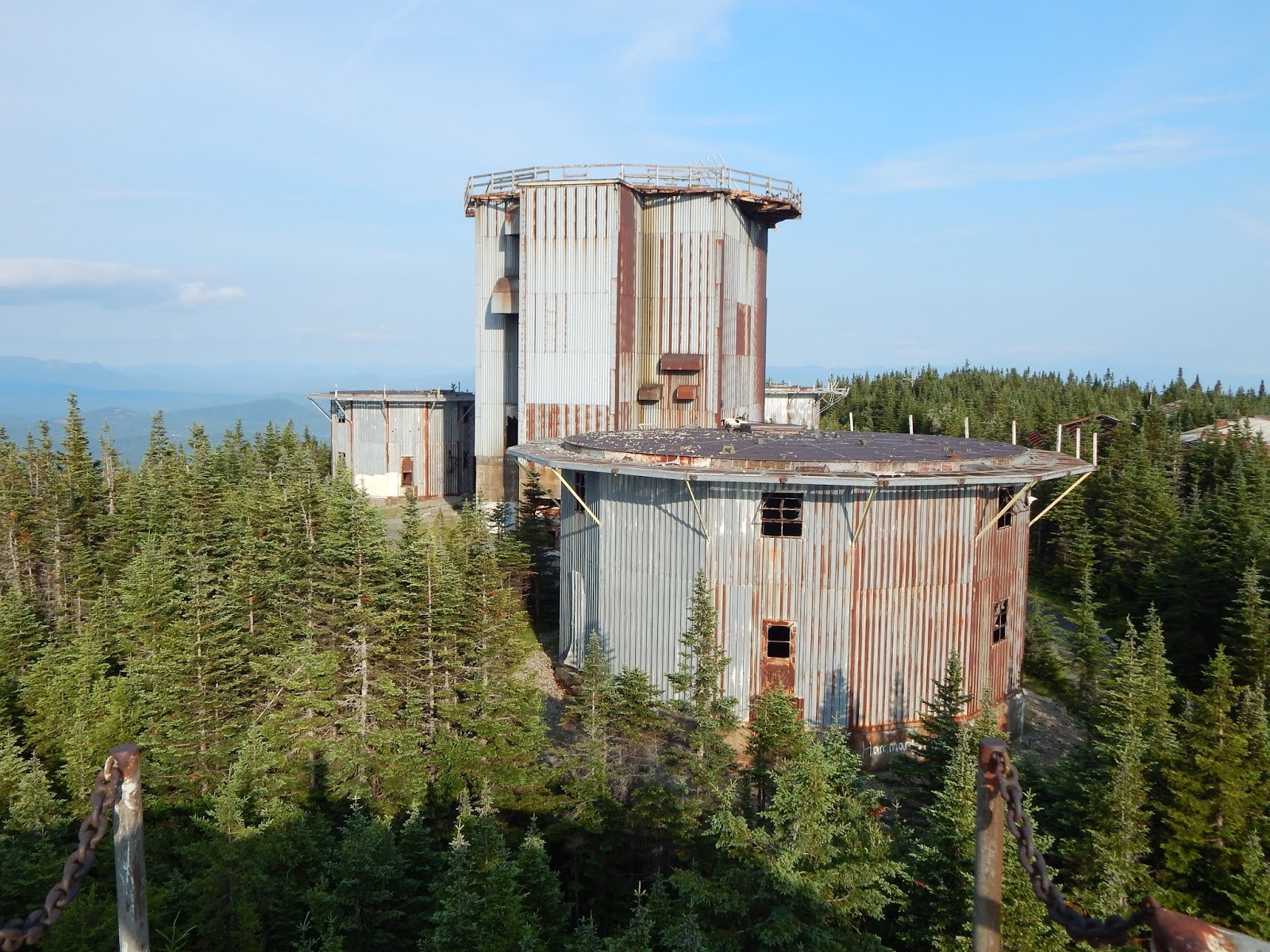
Looking toward the other four towers from the north.
We began the journey driving through Victory State Forest, a very scenic area with views up to Burke Mountain and East Mountain. There are a few scenic stretches of road that pass through meadows along River Road. At one point, the radar towers can be seen.


Looking north toward East Mountain.
Zoomed photo of the towers.
Burke Mountain from River Road.

After the long scenic drive through Victory State Forest, we got to Radar Road, and eventually found ourselves at the base area, otherwise known as the Quonset Village. Since we've been here before, we didn't spend as much time exploring this section of the base.

Mysterious formation along Radar Road.
I've found this area on maps known as Moccasin Mill.
Inside a building.
The gymnasium, which shared the building with a movie theater.
The mess hall.
Looking through the mess hall.
There were several birds flying throughout the structure.
The garage.
The garage was trashed.

The road was the same as last time, easy to follow, winding, and gradual. Surprisingly, we ran into a truck descending the road, which we took as a message to be careful. Looking above the skies were blue, and it took no time for us to reach the summit, where we found the same excellent views from atop the tallest tower.

The blockage, known as The Boulders.
Looking up the road.
On top of the mountain.
Looking south from the tallest tower.

Eventually, we found our way to the northernmost tower, where we set up camp. After carrying everything up and setting it up, we waited for the sun to set. Almost the entire day was spent atop the tower. The views from here are incredible. If you are scared of climbing to the tallest tower, it's worth the little effort to climb this one.


Looking out the window toward the other towers.
The radar towers with the peaks of Nash Stream Forest visible.
Looking northeast toward Seneca Mountain.
Looking toward Burke Mountain and East Haven Mountain.

The horizon began to turn orange, and the sun began to set behind Willoughby Gap and the distant peaks of the northern Green Mountains. The sunset gave the place an eerie yet beautiful feel. The air was still, but even with it being so late, people were still arriving at the summit to explore the area. Once everyone left, the air went still yet again, and the sun slowly set.


Willoughby Gap area as seen before sunset.
The sun setting behind Bald Mountain.
Jay Peak is visible in the far distance to the left.
After the sun has set.
The towers after sun set.

We stayed up late as the skies darkened and all the stars came out. The moon shown brightly, and large distant groupings of lights could be seen from the small villages of northern Vermont and New Hampshire. Darkness fell over the towers and the wind stopped, giving a fearful yet one of a kind feeling to the place. It's as if the tallest tower was just standing there, waiting for the sun to rise, much like us.


The towers with the moon in the background.

After awaking early, we watched the sunrise, which brought life back to the mountain. The towers lit up, the birds began to sing, and the sky filled with light. The skies were a bit hazier than the day before, but we still had excellent views.


View of the sunrise.
The sun rising behind Mt.Blue and Savage Mountain.
The mountains during sunrise. The Percy Peaks are visible to the left,
and the Mahoosuc Range of Maine is in the far distance.

We spent the rest of our time up there walking around the summit area and going to all the other buildings. I hoped that we would be able to climb at least one of the three other towers, but we found that the floors of the others had begun to rot through and were very unsafe. Be cautious when visiting! From here, it was an easy descent.


The northernmost tower.
Another tower, the floor of which is completely rotted.
Looking north at the three towers.
The communications building.
Another building. For more photos, be sure to check out my last blog on East Mountain.

East Mountain is like no other peak in New England, or possibly in the world. The mountain is in the absolute middle of no where, giving the base an eerie vibe, even when other groups are around. I thought visiting the base was a once in a lifetime experience, but now, I've come to the realization that I will likely return numerous times to this location. It's so unique, beautiful and dangerous, all at the same time. There's nothing like it.