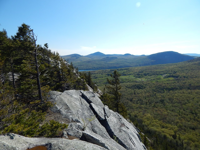
 |
| Lucy on a ledge. |
We started early to avoid crowds, and found the trailhead along Wheeler Mountain Road. The trail began gently through the woods, and we soon came upon the register, and continued forward. The trail wasn't steep at all as it found its way atop the ridge and started to run along the top.
 |
| Always remember to register! |
 |
| Walking along the trail. |
After following the ridge for a while longer, we came upon the first viewpoint, which primarily looked up to the white cliffs of Wheeler Mountain. It looked promising, and I could already tell we were going to get some incredible views. In the distance, Bald Mountain could also be seen, standing tall.
 |
| Looking at Wheeler Mountain. In the distance, Bald Mountain can be seen. |
 |
| A closer look at Wheeler Mountain. |
The path made for a pleasant journey, and eventually entered a meadow atop the southern peak. While there were no major views here, the area was nice, and through the trees, we could see Wheeler Mountain getting closer and closer to us. With it being early morning, it was quiet and peaceful.
 |
| Along the trail with Lucy. |
 |
| Lucy keeps on going! |
Now, the trail began to descend quickly into a col where the old trail came up onto the ridge. It is now blocked off for restoration. From here, the trail climbed one last time until it reached the first ledge. There was a great view from here toward Norris Mountain and Moose Mountain. Wheeler Pond could also be seen below.
 |
| The first view, looking toward Moose Mountain (foreground) and Norris Mountain (right). |
 |
| Looking south from the ledge, with the trail leaving to the right. |
From here on out, the trail was very pleasant. It continued to pass in and out of the trees and onto open ledges with views out to Lake Willoughby and Moose Mountain. There were even some nice views looking down to the valley below and over to the rest of the cliffs along the mountain side.
 |
| The view toward Mt.Pisgah from the second ledge. |
 |
| Looking toward the Stowe area, with Mt.Mansfield visible on the left of the tree. |
 |
| Willoughby Gap from Wheeler Mountain. |
 |
| Bald Mountain from across the cliffs. |
The trail eventually ended at Eagle Rock, the last view along the trail. It's worth mentioning the wonderful view from here. There was an exceptional view looking toward Willoughby Gap, and Mt.Pisgah, Mt.Hor, Moose Mountain, Haystack Mountain, and Bald Mountain. Lake Willoughby, Wheeler Pond, and Sentinel Rock could be seen as well. In the distance, Burke Mountain and East Mountain could be seen.
 |
| Mt.Hor from Eagle Rock. |
 |
| Another view from Eagle Rock. |
 |
| Through the gap, East Mountain is visible, along with one of the radars atop it. |
 |
| Mt.Hor and Moose Mountain with Burke Mountain visible in between them. |
 |
| Sentinel Rock from Eagle Rock. It can be seen in the middle of the left field. |
While this mountain was incredible, it was very quick. Since we had so much extra time, we decided to head over to Sentinel Rock in Westmore. While this isn't a mountain, it's worth mentioning. The rock is large and sits right in the middle of a large field with some beautiful views over to Mt.Hor and Wheeler Mountain. Belvidere Mountain and Jay Peak can also be seen through the trees. It's worth seeing if your in the area.
 |
| The view from Sentinel Rock. Wheeler Mountain is in the center. |
 |
| The rock itself. |
 |
| The trail to Sentinel Rock. |
Wheeler Mountain makes for an incredible hike, and it's safe to say it's probably one of the best hikes in the Northeast Kingdom. It takes no time at all, but gives you an exciting climb that I feel anyone can accomplish. Also, Sentinel Rock is highly worth seeing, with an incredible view and unique history you can only learn by going there. So get out there...
Love the pics & great write up! I especially enjoy the picture of the trail leading to Sentinel rock. Looks like such a pleasant trail to hike.
ReplyDeleteThank you for reading! Glad to see you commenting again!
Delete